Las Vegas & the South Rim

Grand Canyon helicopter tours.

Choose where you start, what you see, and how much of your day you spend in the air.

AI-generated illustration of layered canyon cliffs and a distant river from an imagined Grand Canyon overlook
Grand Canyon AI-generated illustration

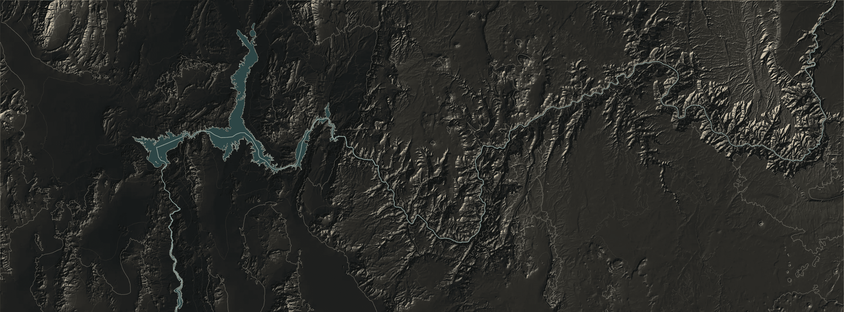
The canyon, on a mapLas Vegas · West Rim · South Rim

Two starting points. Different parts of the canyon.

Las Vegas flights in this guide head to Grand Canyon West. South Rim flights leave Tusayan to see the national park. Locate both before choosing your tour.

Las Vegas & the Grand Canyon North ↑
Lake MeadColorado RiverHualapai Indian ReservationGrand Canyon National ParkNorth Rim
  • Las Vegas Strip 36°07′N 115°10′W
  • BVU Boulder City Las Vegas area · BVU 35°57′N 114°52′W
  • Hoover Dam 36°01′N 114°44′W
  • 1G4 Grand Canyon West Hualapai land · 1G4 35°59′N 113°49′W
  • GCN Grand Canyon Airport Tusayan · South Rim 35°57′N 112°09′W
  • Grand Canyon Village 36°03′N 112°09′W

BVUBoulder City · Las Vegas area

1G4Grand Canyon West · Hualapai landLocation reference; not a canyon-floor landing

GCNTusayan · South Rim

Airport locations, not flight paths. The West Rim and South Rim are different destinations.

Map key & sources

Dashed: National Park Service boundary. Dotted: Hualapai Indian Reservation (US Census Bureau).

Relief: USGS 3DEP / SRTM. Contours: 250 m. Water: USGS National Hydrography Dataset; mapped water extent is not a live reservoir shoreline. Scale at 36.06°N.

Airport reference points: FAA data via AirNav. Use your operator’s directions for check-in. Cartography by Helicopter Tour Finder; checked 10 October 2026.

This is a geographic guide. Airspace restrictions and individual tour routes are not plotted. See the FAA’s Grand Canyon chart for aviation information. Not for navigation.

3 flights covered so far, from two airports. Choosing a starting point highlights it on the chart above.

Departure directoryFAA airport data

Where Grand Canyon helicopter tours take off

“Grand Canyon helicopter tour” covers flights from very different airports. The Las Vegas tour in this guide leaves Boulder City for Grand Canyon West, on Hualapai land. Other operators also use Las Vegas-area heliports. Flights at the South Rim leave from Grand Canyon Airport in Tusayan and visit the national park’s canyon. They are two different trips.

Departure airports for the helicopter flights we have checked
Ident Airport Elevation Clock Flights we have checked
GCN Grand Canyon National Park Airport Tusayan, Arizona. 6 miles south of Grand Canyon, Arizona (FAA); outside the national park. Papillon South Rim terminal 6,609 ft2,014 m Arizona time, UTC−7 all year North Canyon, Grand Kingdom
BVU Boulder City Municipal Airport Boulder City, Nevada. 1 mile southwest of Boulder City (FAA). Papillon Boulder City terminal, 1265 Airport Rd 2,203 ft671 m Pacific time, observes daylight saving Grand Celebration
1G4 Grand Canyon West Airport Grand Canyon West, Arizona. On Hualapai land, outside the national park. 4,817 ft1,468 m Arizona time, UTC−7 all year Grand Canyon West is the viewing region for our Las Vegas landing tour. Local departures are not covered yet.
Sources & research notes

Cross-sectionsUSGS elevation data

Air-only or landing: above the rim, or below it

The flights we have checked at the South Rim stay in the air. Over the national park, large parts of the canyon are flight-free zones, most of them from the ground up to 14,500 ft, and tour flights cross through designated corridors. The landing tour from Las Vegas sets down far below the rim at Grand Canyon West, outside the park.

Grand Canyon Village to the North Rim: cross-section Grand Canyon Village to the North Rim. Near rim about 6,970 ft, colorado river crossing about 2,410 ft, far rim about 8,220 ft. Heights are estimates from the elevation model.
Colorado River crossing, about 2,410 ft South Rim: Grand Canyon Village to the North Rim. The air tours we cover cross without landing. Air tours use authorized corridors; airspace rules include altitude exceptions (14 CFR 93.305) Elevations from USGS 3DEP / SRTM along a straight transect. River crossing from USGS hydrography. Vertical scale exaggerated about 3.3×.
Across the canyon at Grand Canyon West: cross-section Across the canyon at Grand Canyon West. Near rim about 4,810 ft, colorado river crossing about 1,160 ft, far rim about 4,820 ft. Heights are estimates from the elevation model.
Colorado River crossing, about 1,160 ft Grand Canyon West: across the canyon near Grand Canyon West Airport. Elevations from USGS 3DEP / SRTM along a straight transect. River crossing from USGS hydrography. Vertical scale exaggerated about 2.9×.

One flight, timedPapillon · PBW-4

How long a Las Vegas canyon trip takes

Papillon’s Grand Celebration lists about 70 minutes of flying and about 30 minutes on the canyon floor inside a 4–4½-hour trip from your hotel. The rest of the day is the shuttle, check-in and waiting, which Papillon does not break down.

Boulder City to Grand Canyon West Papillon · PBW-4

Grand Celebration

A below-rim landing that you can reach from a Las Vegas hotel without driving.

Trip composition · duration, not sequence

Flying within the whole trip

70minutes flying

4–4½ hhotel to hotel

  • Flying70 min
  • Below-rim stop30 min
  • Shuttle, terminal & waiting2 h 20–50 minderived remainder

The 70 minutes includes both flights. The dotted remainder is calculated from the published total; individual shuttle and terminal times are not itemized.

The view
Hoover Dam, Lake Mead and Grand Canyon West, on Hualapai land outside the national park
The landing
Lands on a plateau about 3,200 feet below the rim near the Colorado River, with about 30 minutes on the ground, champagne and a light picnic.
Airport details & visit steps
Departure
Papillon Boulder City terminal, 1265 Airport Rd, Boulder City, Nevada · BVU, 2,203 ft elevation
Transport
Round-trip shuttle from selected Strip and Downtown hotels, picking up about 60–90 minutes before departure.
Keep in mind
About 70 minutes of flying sits inside a 4–4½-hour trip, and it visits Grand Canyon West, not the national park’s South Rim.
Sources & research notes

ContentsEdition 1

Contents

  1. South Rim helicopter tours from Tusayan Region

    The airport, the corridors, and the short and long flights.

  2. North Canyon vs Grand Kingdom Comparison

    What the longer South Rim flight adds, and what stays the same.

  3. Flight time vs tour time Guide

    Three ways a tour time is measured, and how to plan a day around one.

  4. How we research and check flights Method

Tour details checked against Papillon’s published information on . Each flight brief links to its sources; confirm current details with the operator before booking.

View the source log